 |
|||
| Local Partners (on the Recovery Observatory Steering Committee) | |||
The Recovery Observatory in Haïti in short
Globally, in both developed and developing countries, disasters strike regularly. Disasters sometimes take on catastrophic proportions, whether because of particularly vulnerable populations or a dramatic natural event. Hurricane Katrina, the 2010 earthquake in Haiti, Typhoon Haiyan and the Great East Japan Earthquake and Tsunami are examples of disasters that hold a special place in our collective memories. Hurricane Mathieu, which hit southwestern Haiti on October 4, 2016, is an event of grave magnitude, with a lasting impact, especially for Macaya Park, the country's largest biodiversity reserve.
|
|
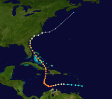
On October 4, 2016, Hurricane Matthew struck southwestern Haiti, the first category 4 hurricane to hit Haiti since Hurricane Cleo in 1964. The toll was 546 lives lost, 128 missing, 439 injured and 2.1 million people affected by the cyclone, including 895,000 children. Matthew's impact is still present today and it will be lasting. While the floods caused extensive damage and loss of life, the main vector of destruction was wind, in some areas it destroyed over 95% of buildings and completely decimated trees and agriculture. Furthermore, the environmental damage is widespread. It should be noted that the most affected area has the largest concentration of natural protected areas in Haiti. * Figures from the Post-Disaster Needs Assessment Report for Hurricane Mathieu: PDNA (Government of the Republic of Haiti with the support of the United Nations System, the European Union, the Inter-American Development Bank and the World Bank) |
In December 2016, the Committee on Earth Observation Satellites (CEOS) created a Recovery Observatory or RO, co-chaired by CNES (Center National d'Etudes Spatiales in France) and the Haiti National Geospatial Information Center (CNIGS in Haiti), in close partnership with other Haitian organizations, international donors such as the World Bank, UNDP, and the European Union, as well as other space agencies. By relying in particular on the Copernicus "Risk and Recovery" program, the RO was able to demonstrate the benefits of better integrating information from satellite images into the recovery process. The work of the RO will end in December 2020.
Recovery Observatory Area and Works
Co-constructed with Haitian partners, the RO regularly organizes workshops in Haiti. These workshops made it possible to define the needs for cartographic products, and to organize their improvement as well as their validation, which is carried out directly by the Haitian partners. Since early 2017, satellite imagery products have been developed along the following themes:
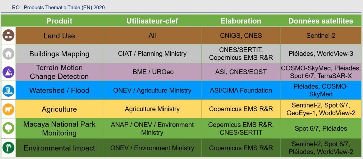
For each of these themes, a local champion has been designated, sometimes two, to supervise the progress of the work of each theme and to act as a relay for local actors. In each of these themes, products are produced and a capacity building component is set up to enable local actors to be able to understand their use.
The objective of the RO is to make it possible to see in a clear and synthetic way the state of a given zone, according to a chosen theme, before the event, immediately after the event, and at regular intervals during the recovery period.