The Context
Many ground movements exist in Haiti, often of low intensity, in terms of surfaces or speed. Nevertheless, the cumulative area affected following a major forcing event (heavy rain, earthquake) can be significant with significant erosion rates, losses of arable land, and damage in the alluvial plains by sediment transport. . Little information exists, and ground movements are not listed. The BME began the creation of an atlas of land movements but this is impossible without automation.
Work done by EOST, contract CNES
Imagery (provider) : Spot 6/7 (CNES)
Products
-
Detection and characterization of ground movements in the OR area triggered by hurricane Matthieu
-
Development of a method of automatic detection of the movements of ground.
For the post-Matthew ground motion inventory map, the product derived from optical satellite imagery (ALADIM algorithm and imCLASS) is validated against an expert geomorphological inventory resulting from an image-interpretation.
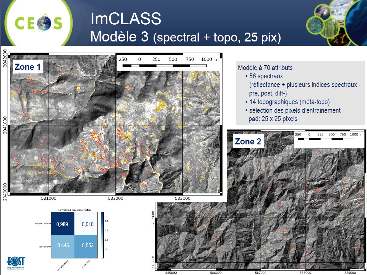
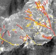
Extract of result of the ImCLASS algorithm, Presentation Workshop RO 2019
In Red the identified Ground Movements, in Yellow detected by ImCLASS
Transmission of products
The Post-Matthew Terrain Movement Inventory Map will be transmitted as a vector file to BME and CNIGS.
Feedback from experience
Inventory of ground movements triggered by Hurricane Matthieu in the Department of Grande Anse / East of Macaya Park
There is a methodological lock for the automatic identification of ground movements because the landslides are mostly small (on the surface, of the order of a few hundred m2), connected to the main thalwegs (hence problems of misclassification with river sediments), and very similar (in terms of radiometry) to bare soils or agricultural land. Automatic identification in areas under cloud shade is also difficult. It would be necessary, in the case of possible annual production of inventory maps, to have an annual image coverage systematically taken at the same time to obtain similar conditions of sunshine and vegetation conditions.
An experience feedback with CNIGS and BME must be done to define the technical characteristics (periodicity of update, precision sought, size limit of the cartons, etc.).
Final delivery is available in the attached files :
- Intermediate presentation of the work (April / Mai 2019 Workshop)
- The results of the classification by segment (ALADIM) in shp format and in tif format
- The results of the pixel classification (IMClass) in tif format (and proba in tif format: part 1 / part 2)
- Final Delivery (October 2020)
- digitalisation.shp : interpretation reference work made by the student Melyssa Reynaud
- training_areas.shp : areas used for Random Forest training
- resultats_seuil05_W7_poly.shp : ALADIM shapefile result after post-treatement (morphological operations - erosion / dilation, thresholding, binarization and polygonization - binarized probability at 0.5 (beta score))
- results_classif_per_pixel_proba_20200828_210837.tif : ImCLASS result : landslide occurrence probability map and * _open_close file: probability map after morphological operation
- results_classif_per_pixel_binarized_threshold_0.632_20200828_211059.shp : ImCLASS result - shape file post binarisation (optimal threshold evaluate at 0.632)
- results_classif_per_pixel_majority_vote_on_segment_20200829_010008.shp : ImCLASS result- shape file after majority vote (of the binarized pixel map with the optimal threshold) on segments resulting from a segmentation of the BGRN + NDVI + proba layers.
- Final Report and annexes (french only)