
This page lists all the information, the exchanges and the products around the subject of the Change detection and Ground Movement
Following Hurricane Matthew and the torrential rains that accompanied it, numerous landslides occurred in the southwest area. It was important to identify these landslides, and to understand the evolution of risk in the affected area. In fact, the extreme violence of the rains has permanently destabilized certain formerly stable areas.
In addition many illegal quarries seem to exist in different places, some of them are potential risks of movement of land around roads or electrical installations. The various follow-ups of these phenomena would allow their controls and preventions today impossible.
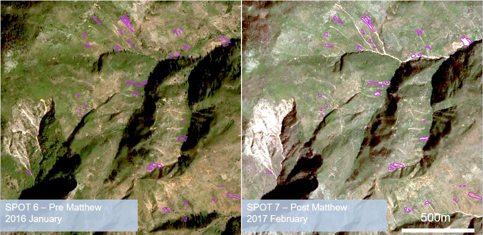
Example of an algorithm for detecting ground movements in Les Anglais (ALADIM, CNES/EOST)
The RO team linked researchers from the international community with representatives of the Bureau of Mines and Energy (BME), and two separate methodologies were deployed to record terrain displacement, first immediately after Matthew, then in the months and years that followed. One methodology is based on optical imaging analysis (ALADIM), undertaken in partnership with the University of Strasbourg. The second is based on Cosmo-Skymed and Sentinel-1 radar imagery, in partnership with the Italian Space Agency (ASI). These two methods are complementary and their combined results should provide a consolidated product.
Three areas have been identified to monitor ground movement: Jérémie, the Camp Perrin - Jérémie axis, and an area around the Arniquet quarry. The main objective for these three zones is the detection and characterization of changes and ground movements. To this main objective is a second and more exploratory objective, namely the detection and the monitoring of quarries (legal and illegal).
Thematic leads :
MTPTC / BME, Samuel Genea
URGeo, Steeve Symithe
UNDP, Samira Philip
Work done by Italian Space Agency (ASI) and CNES/EOST
Imagery (provider) : Pléiades (CNES), Cosmo-SkyMed (ASI), Change Detection : SPOT6/7 (CNES), TerraSAR-X (DLR)
Analysis of Results and Outlook :
The two methodologies made it possible to map landslide sites, and in some cases to establish a relationship between susceptibility to landslides and prevalent agricultural practices. This result is of great interest for the BME, as Haiti suffers from significant land degradation and soil erosion problems.
In addition to the landslides linked to Hurricane Matthew, the BME has identified a need to identify unauthorized mining quarries exploited throughout the country.
These same methods are found to be effective in identifying large quarries but do not have sufficient resolution to identify small quarries. In 2020, training for Haitian partners using the two methodologies is planned, as well as sharing of imagery exploitation techniques. All the tools will be available on ESA’s GEP (Geohazard Exploitation Platform), which offers cloud-based processing at the site of data storage, allowing remote processing from Haiti.
In the future, these tools can be used both to detect changes after hurricanes and earthquakes, and to track the unauthorized exploitation of quarries.
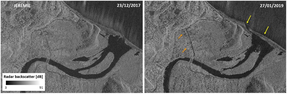
1 m SAR change detection along Grand'Anse river in Jérémie, Haiti. COSMO-SkyMed® Products ©ASI 2018. All Rights Reserved (ASI RO-Haiti license).
List and links of elaborated products :
2020 Oct - (CNES/EOST) Automatic detection of ground movements from optical imagery
2020 Jan - (ASI) Observing surface deformation with Sentinel-1 in GEP
2019 Aout - (CNRS-EOST) New GEP services for landslide detection and mapping
2018 Aug - (CNES/LIVE) Career Detection Internship
Here are some useful data available :
Last updater : Data from the GPS Station of Camp Perrin are available here (.pos .res and .ps) Thank to Renaldo Sauver - CNIGS
The Geological Map of Haiti is available here
GNSS/GPS Stations
September 2017 progress of the GNSS / CORS station network :
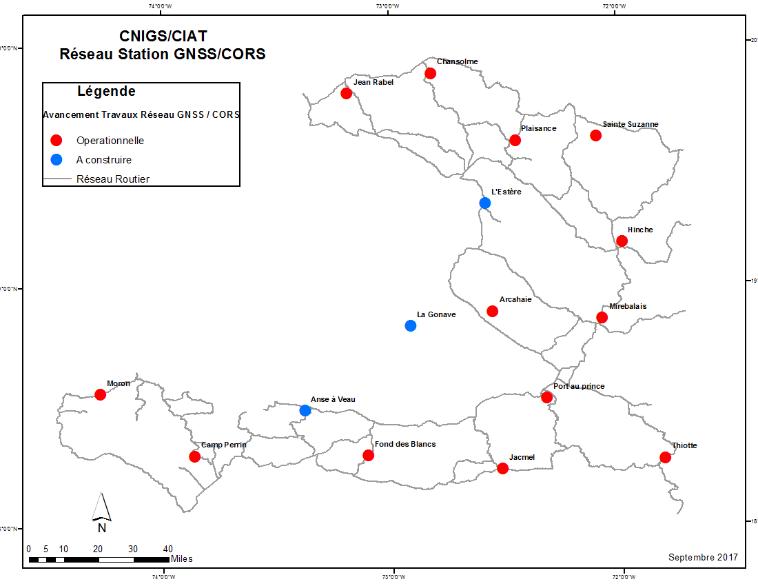
. The coordinates of all stations: Shape file
. The station data is available on the following link:
ftp://data-out.unavco.org/pub/rinex/
. The description of the station data is available on the following link:
http://www.unavco.org/data/gps-gnss/ftp/ftp.html
. A site has been set up by the CNIGS on the donenes stations (soon available ...):
http://www.cors.cnigs.ht/
Land Movement Threats Map - March 2010
The Government of Haiti, with the support of the World Bank, the Inter-American Development Bank and the United Nations system, published a map in March 2010 on determining levels of multiple natural threats in Haiti.
- The Detailed Repport here -
- The Map is available here -
Risk information map on the Department of Grande Anse - 2017
UNDP has produced an information map of natural hazards on the Department of Grande Anse including seismic risk, flood and land movements :
- The Map is available here -
- kmz files are here -
Risk Reduction Plan in Urban Area : Jérémie 2017
The PRRNU is composed of: apresentation report, a zoning of good use of the soil and a regulation of good use of the soil specifying the measures that are applied in the matter of construction, development, exploitation over all zone (prohibitions, authorizations, conditions ...)
- The Detailed Presentation here -
Atlas of natural threat in haiti - CIAT 2017
This Atlas was produced by the Bureau of Geological and Mining Research (BRGM, France) in coordination with the Interministerial Committee for Territorial Development (CIAT) with funding from the World Bank (WB) and the World Facility for the Prevention of Wildlife. Disaster Risk and Recovery (GFDRR, acronym in English).
Mission report following the landslides that occurred in January 2018 in Jean-Rabel
The BME conducted a mission to Jean-Rabel (Northwest of Haiti - outside RO area) to assess the landslides occurring after rainy episodes in January 2018. This report includes an analysis of the general predisposition of the terrain, a description observed landslides, their types as well as photos.
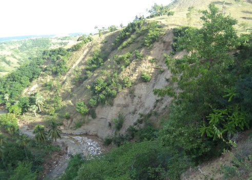
Bank of the Coicou River, outcrop of nearly 10m high, flysh,
near the slope destabilized by a landslide

