2019 - Agriculture on the Plain of Les Cayes / WB Project
In the second half of 2018, the World Bank launched a study on improving climate resilience and productivity in the Plaine des Cayes. This study carried out by the group of the Canal Society of Provence, Genie Conseil Terro and Geograph'R was conducted until early 2019.
The publication of the report and the key data will be communicated on this page as soon as it is released.
![]()
In its press release of March 2019 La Telescop has already informed of its coming to the Living Planet Symposium on May 15, 2019 for the presentation of a poster on the work done.
Translation of the release (visible in French here) :
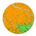 |
In collaboration with SCP and GeographR, the Production division participated in the development of land use maps on the plain of Les Cayes in Haiti for the World Bank. Created from CIRAD's Moringa automated processing chain, these maps are used for the study on improving climate resilience and productivity after the passage of Hurricane Matthew. This production will be the subject of a poster presented in the "Risk Management" session on May 15, 2019 at the Living Planet Symposium organized in Milan by the European Space Agency. |