The Context
Following the many storms and hurricanes descending on the Haitian coast, the coastline is changing rapidly in a few years, retreating in some areas, progressing in others. Sometimes whole sections of coast disappear as was the case near Port-Salut following the hurricane, taking with it the neighboring houses.
The delineation of the country's coastline has already been done using data from 1978, 2002 and 2010.
Products
The purpose of this product is to follow the evolution of the coastline to identify current trends, and warn the municipalities and thus regulate the human presence in these areas with strong dynamics. The expected products are both the maps of the coastline but also its evolution compared to previous references.
During the Copernicus EMS R&R 051 activation different maps were produced :
- 1 coastal line delineation map (from Jérémie to Les Cayes)
- 1 coastal line evolution map (from Jérémie to Les Cayes)
| Map layers | Coastal line delineation map | Coastal line evolution map |
| Coastal line (archive) | X | |
| Post-Matthew coastal line | X | |
| Coastal line evolution | X | |
| General topography (infrastructure networks, urban, buildings, hydrographic network, Industry and facilities, contours and spot heights, shaded relief) | X | X |
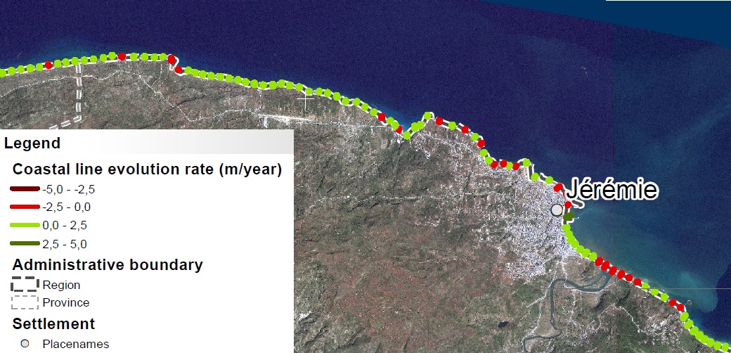
Extract from Coastal line evolution around Jéremie (Map EMSN-051 Copernicus/EC)
Transmission of products
The maps produced and the corresponding files were sent to CNIGS, CIAT and ONEV for printing and local distribution.
A training session was held in December 2018 to train the experts in the production and operation of the product and the corresponding database. The methodology was presented, then a practical work was realized. The CNIGS has also benefited from databases and cartographic products.
A Technical Note concerning the moethod used has been prepared :
Technical Note on the digitalization of the coast line (FR)
April 2019
Feedback from experience
The use of SPOT-6/7 data is very suitable for this work because two images acquired during the same passage cover the entire study area. In addition, this ensures homogeneity both on the type of sensor used, and on the height of the sea (i.e. tide).
In addition, having a database of shoreline position over several decades is relatively valuable. From this perspective, however, it is necessary to adopt a common methodology in the layout of the coastline.
For more information on EMSN 051 Activation :
https://www.recovery-observatory.org/drupal/en/groups/activation-copernicus-ems-rr/emsn051-rural-areas
or
https://emergency.copernicus.eu/mapping/list-of-components/EMSN051
Find the maps products below :
| [EMSN051] Jeremie to Les Cayes: COASTALLINEEVOLUTION(OVERVIEW) | ||
 |
Published: 2018-11-23 00:00:00 (UTC)
Product version: v2
Map scale: 1:135000
Status: Production finished
|
Downloadable items
PDF: 300 DPI
|
| [EMSN051] Jeremie to Les Cayes: COASTALLINEDELINEATION(OVERVIEW) | ||
 |
Published: 2018-11-23 00:00:00 (UTC)
Product version: v2
Map scale: 1:135000
Status: Production finished
|
Downloadable items
PDF: 300 DPI
|
Find the Vector Data below :