The EMSN051 demand aims to support and assist the monitoring of post-hurricane recovery Matthew on October 4, 2016 in six selected areas with analyzes of several environmental aspects, including agricultural activities, protected forest areas and hotspots. mangroves. The goal is to build a comprehensive database to organize recovery assistance and monitor the recovery of critical resources destroyed. The areas of interest cover several locations in the southern region of Haiti, from Jeremie to Makaya Park, Port-Salut, Les Cayes and Abacou Point (Figure 1). In this zone, the coastal line must also be approached between the cities of Jérémie and Les Cayes (nearly 250 km from the coast).
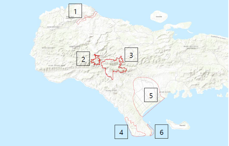
Copernicus EMSN051 demand Areas of Interest
Here is the list of requested themes and related products:
Agriculture (Zones 1,4 & 5)
- A detailed cartographic product of agricultural activities in certain areas of interest. A preferred crop classification product, including a set of attributes, not limited to crop type, area, information if a field was active or managed, and other information on seasonality. This product must present a status of agricultural activities prior to the event and serve as reference information.
- A second detailed cartographic product of agricultural activities in certain areas of interest. => Update of the reference
- The state of agricultural land and its change, when current land use data are compared to the baseline, collected before the event. This product should conclude the change in land use, land conversion, land abundance etc.
Coast line
- An evolution product of the costal lines will be created, along the coast, between the cities of Les Cayes and Jérémie. The timestamp of image data for this product is preferable from 2017. This dataset should contribute to the existing historical study of coastal evolution based on several archival measurements dated from 1998 (20m), 2002 (1m) and 2010 (30cm / 1m). The methodology used for the creation of archival measures will be provided by the CNIGS.
Macaya Park (Zone 2 & 3)
- Classification of forest stands and vegetation prior to the event in Macaya Park, CNIGS nomenclature for future comparison.
- Assessment of damage to forest stands (consisting mainly of broadleaved, coniferous, karst and mixedwood) in the protected area of Macaya Park.
- An annual monitoring product of Macaya Park, which shows how regeneration is taking place and identifies remaining old stands to support protection activities. As a result, monitoring information will be provided, including vector data, statistics and reports. The time interval is set at 12 months after the event to show the state of recovery and rehabilitation.
Mangrove (Zone 6)
- Pre-event situation of the zone related to mangrove vegetation.
- Assessment of damage to mangroves in the selected area. The analyzes will cover the current situation to support possible reforestation activities and provide vector data with cross-tabulations of forest assets of all types and impact. Relevant global statistics should also be provided in the report.
Following this request the Copernicus Service has launched the activation EMSN051, you will find the final technical report below:
The list of products is available here (Version 2) :


