
This page lists all the information, the exchanges and the products around the subject of Environmental Impact.
During the passage of cyclone Matthew in the departments of Grand'Anse, Nippes, and South, the maximum wind speed recorded reached 230 km/h, causing heavy flooding (more than 600 mm in less than 24 hours) and waves from storm surges. An increase in sea level of 2 to 3 meters on the south coast is estimated. The environment of these departments has been severely affected; natural ecosystems have been ravaged. The purpose of this activity is to analyze the effect from Matthew and to observe the recovery, or not, of natural ecosystems along two main sub-themes: monitoring coastal changes; and assessing Hurricane Matthew impact on mangroves, and then evolution of their state over time.
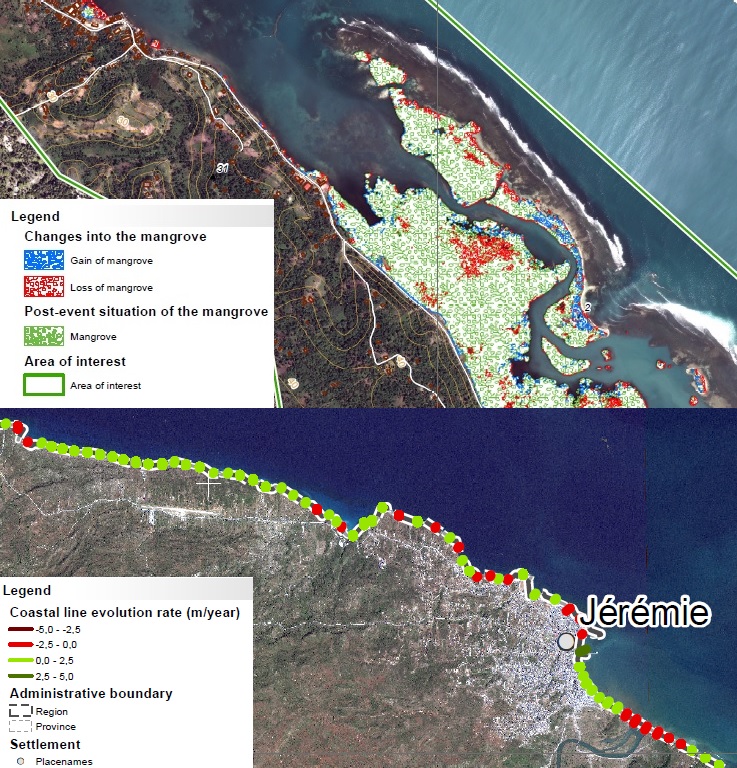
Extract from the monitoring of the Mangrove at Pointe Abacou and Coastal line evolution around Jéremie (Map EMSN-051 Copernicus/EC)
Following the Haitian request, in addition to the Macaya Park which occupies another theme, two main topics were studied: the evolution of the coastline from Jérémie to Les Cayes and the monitoring of the mangrove of the "point d'Abacou". The objective is to analyze the changes following the hurricane and to identify current trends to inform municipalities.
Thematic leads :
CIAT, Rose-May Guignard
ONEV, Dwinell Bélizaire
CNIGS, David Telcy.
Work done by Copernicus / European Commission
Imagery (provider) : Pléiades (CNES), SPOT6/7 (CNES), Sentinel-2 (EU), WorldView-2 (EU)
Analysis of Results and Outlook :
The coastline product showed significant impact of the hurricane on the entire coastal area. The methodology used has been documented and transferred to CNIGS, so that it can directly produce updates.
The mangrove product seemed to indicate that the mangrove had changed little after the hurricane. Specialists from UNEP and the IDB annonce their respective interests for this type of product with a larger scale. The current methodology allow regular monitoring of vulnerable mangrove areas, but remains to be applied over larger areas, even the entire Haitian coast, but also and above all over longer periods of time.
List and links of elaborated products :


