
This page lists all the information, the exchanges and the products around the Watershed and Flood
In the weeks following Hurricane Matthew, the watersheds were cluttered with debris. This situation raised fears of blockages and jams, in case of renewed bad weather. The scientific products Watershed and Flood are produced with the aim of obtaining maps of the flood hazard and exposure layers of the RO territory of Haiti. They will take into account changes in exposures according to satellite change maps and assessment of potential damage for certain risk scenarios derived from the maps (flood risk).
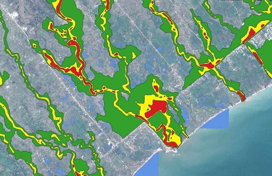
Example of a flood risk map around Les Cayes
The reduction of the vegetation cover implies in the long term a strong erosion of the grounds, but also a more important run-off during the rainy episodes that are the cyclones or storms, unfortunately current in Haiti. These runoff and erosions constitute a high risk for the populations generally concentrated in the bottom of valley or plain (like the plain of Cayes), being then at the front line during these events.
The areas monitored are the catchment areas of Les Cayes, Cavaillon and the Jérémie watershed. The watersheds concerned have been modeled so as to be able to integrate analysis layers into the RASOR multi-risk analysis tool.
In the event of a new cyclone event, plans were made to acquire very high-resolution Cosmo-Skymed images and compare them with archive images to detect changes in the watersheds of major rivers in the area. These images can be displayed in the RASOR risk analysis tool. No new event occurred in the area during the RO project period, but the contribution in terms of watershed modeling was considered useful.
Thematic leads:
MPCE / CNIGS Jean-André Pierre
MPCE / CNIGS Pradel Formonvil
Minister of the Environment
Work done by the CIMA Research Foundation, ASI funding
Imagery (provider) : Pléiades (CNES) , Cosmo-SkyMed (ASI)
Analysis of Results and Outlook :
Two major pieces of information are expected: a risk map for the different basins and a flood hazard map. These maps are an essential starting point for the implementation of a flood risk prevention plan, from a territorial planning perspective. The realized products will be made available via the RASOR platform through the implementation of flood risk maps and exposure layers.
The RASOR tool is available for the area and makes it possible to simulate the impact of events, especially on the catchment areas impacted by Matthew. See: http://www.rasor.eu
List and links of elaborated products :
