The Context
The multiple storms and hurricanes descending on the Haitian coast have the effect of modifying from year to year (and sometimes strongly) the coastline, or to ravage the forests because of the violent winds. The mangrove lies in these two cases during such bad weather.
Products
The purpose of this product is to follow the evolution of the mangrove so as to identify current trends and warn municipalities to regulate the human presence in these high-growth areas and potentially support reforestation campaigns. The expected products are both maps of the mangrove areas but also their evolution compared to the previous reference.
During the Copernicus EMS R&R 051 activation different maps were produced :
- 1 pre-Matthew situation map of the mangrove at Pointe Abacou
- 1 post-Matthew situation and change map of the mangrove at Pointe Abacou
| Map layers | Mangrove delineation map | Mangrove evolution map |
| Mangrove (Pre-Matthew) | X | |
| Mangrove (Post-Matthew) | X | |
| Changes into the mangrove | X | |
| General topography (infrastructure networks, urban, buildings, hydrographic network, Industry and facilities, contours and spot heights, shaded relief) | X | X |
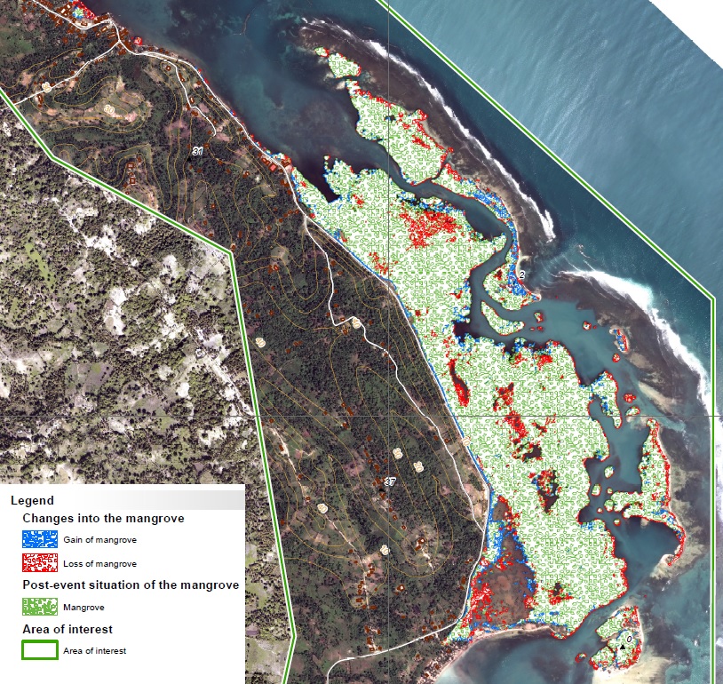
Extract from the monitoring of the Mangrove at Pointe Abacou (Map EMSN-051 Copernicus/EC)
Transmission of products
The maps produced and the corresponding files were sent to CNIGS, CIAT and ONEV for printing and local distribution.
A training session was held in December 2018 to train the experts in the production and operation of the product and the corresponding database. The methodology was presented, then a practical work was realized. The CNIGS has also benefited from databases and cartographic products.
Feedback from experience
The mangrove is easily identifiable to the naked eye by the photo-interpreter. On the other hand, it is very complex to separate from the rest of the woody vegetation. To carry out a fine extraction, it is necessary to work within a binary mask previously cut by hand by the expert. The use of this mask is also necessary to exclude areas of accumulation of algae (i.e. sargassum).
As part of the study conducted on the evolution of the mangrove between 2016 and 2018, it appears that there is no significant evolution that can be attributed to Hurricane Matthew.
For more information on EMSN 051 Activation :
https://www.recovery-observatory.org/drupal/en/groups/activation-copernicus-ems-rr/emsn051-rural-areas
or
https://emergency.copernicus.eu/mapping/list-of-components/EMSN051
Find the Maps products below :
| [EMSN051] Pointe Abacou: MANGROVEPREEVENTSITUATION(OVERVIEW) | ||
 |
Published: 2018-11-23 00:00:00 (UTC)
Product version: v2
Map scale: 1:10000
Status: Production finished
|
Downloadable items
PDF: 300 DPI
|
| [EMSN051] Pointe Abacou: MANGROVEDAMAGEASSESSMENT(OVERVIEW) | ||
 |
Published: 2018-11-23 00:00:00 (UTC)
Product version: v2
Map scale: 1:10000
Status: Production finished
|
Downloadable items
PDF: 300 DPI
|
Find the Vector Data below :