
This page lists all information, exchanges and products around the theme of buildings mapping
One of the first concerns following Matthew was to understand the impact of damage to buildings, especially in the two largest urban centers in the affected area, Jérémie and Les Cayes.
The damage assessment carried out following Matthew, in the emergency response phase, found significant damage. More than 95% of the roofs had been torn off by strong winds. Satellite imagery acquired before and after the event confirmed this finding.
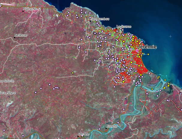
QL map of buildings states pre/post Matthew Hurricane (CNES/SERTIT),
in red the heavily affected buildings, in green a priori not impacted
During the first user workshop of 2017 the two main areas identified by Haitian actors were the two main cities: Jérémie and Les Cayes. It seemed neccessary to make a current state of the built. For this different mapping was necessary: a pre-hurricane state, a post-hurricane state (at the most temporally close), then an update 6 months and a year later depending on the satellite images available.
Given the size of the two zones, a first study was produced in 2017 by iCube-SERTIT with CNES funding on the Jeremie area, in order to validate the methodologies commonly used for this type of product, and to have initial feedback from users. This study was presented at the end of 2017 during the technical workshop in Haiti and updated at the beginning of 2018 following the return of the actors.
The entire mapping of buildings in the Jérémie and Les Cayes areas was subsequently carried out during the Copernicus call EMSN050, which allowed the generation of detailed impact maps on buildings in Jérémie and Les Cayes, and especially maps showing the reconstruction post-Matthew. These maps were provided to local authorities to validate the content and the approach.
Five dates were used according to the available images:
| 2014 | 08/15 Oct 2016 | Feb-Mar 2017 | 15 Dec 2017 | 05 Feb 2018 |
| Aerial Orthophoto Images CNIGS | Pléiades-1B, SPOT-7, WorldView-3 | Pléiades-1B, SPOT-7 | Pléiades-1B | Pléiades-1B |
More than two years after the event, recovery in the construction sector is completed, and the issues at hand are now standard growth and development. RO products dealing with building damage were not produced again after 2018.
Thematic leads:
CIAT, Rose-May Guignard
MPCE / CNIGS, Gabriel Jean Baptiste
Work done by CNES/SERTIT, Copernicus / European Commission
Imagery (provider) : Pléiades (CNES), OrthoPhoto (CNIGS), WorldView-3 (EC)
Analysis of Results and Outlook :
The products supplied arrived a year after the event, they contributed to evaluation of the reconstruction process, allowing to observe an evolution in urban growth following the hurricane, especially along the road from the airport to Jeremie, often in areas of gullies. With regard to individual buildings, the use of optical satellites is proving difficult in areas with dense vegetation. It was also noted that there was no systematic relationship between the damage observable on the roofs and the damage to the rest of the building. It is important to calibrate the observations from space with ground data via ground surveys.
In the future, one product noting the damage in the days after the event, and one or two products two months and six months after the event could be enough, given the dynamics of housing reconstruction, especially the most precarious.
List and links of elaborated products :
2019 Apr - (CNES) Incorporation of Remarkable Points and Update of Nomeclature
2018 Sept - (Copernicus/EU) EMSN050 : City states and indentification of camps
2018 May - (CNES) Inventory on the City of Jérémie

