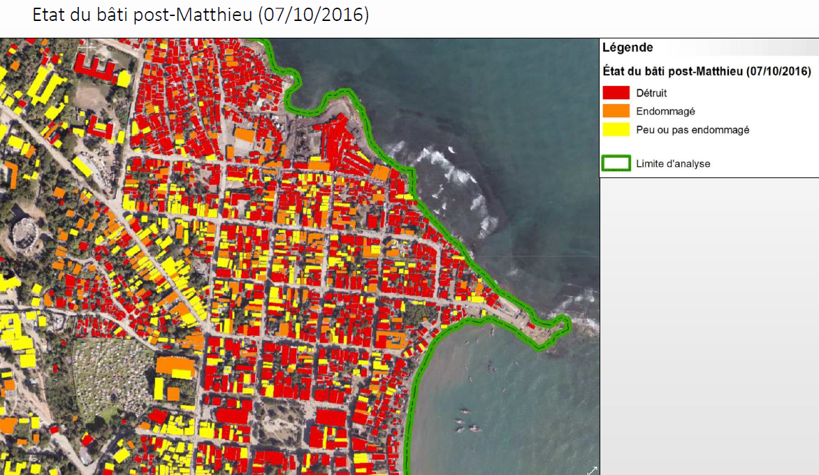
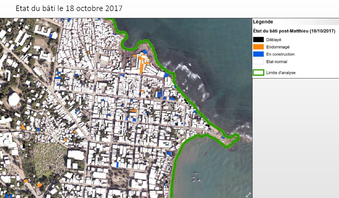
The purpose of this study is to carry out an inventory of buildings at the scale of the city of Jérémie. This inventory is carried out on three different dates, in order to obtain a database characterizing the state of the building according to three time points: a pre-Matthew state, an immediate state after the passage of Matthew, and a post-Matthew state ( in this case one year later). This work however required the availability of optical imagery with very high spatial resolution, the quality of which must be able to allow photo-interpretation.
Work done by SERTIT, contract CNES
Imagery : CNES
| T0 | T1 | T2 |
| Ortho-Aerial Photography (25cm) 2014 |
Pléiades (70cm) |
Pléiades (70cm) |
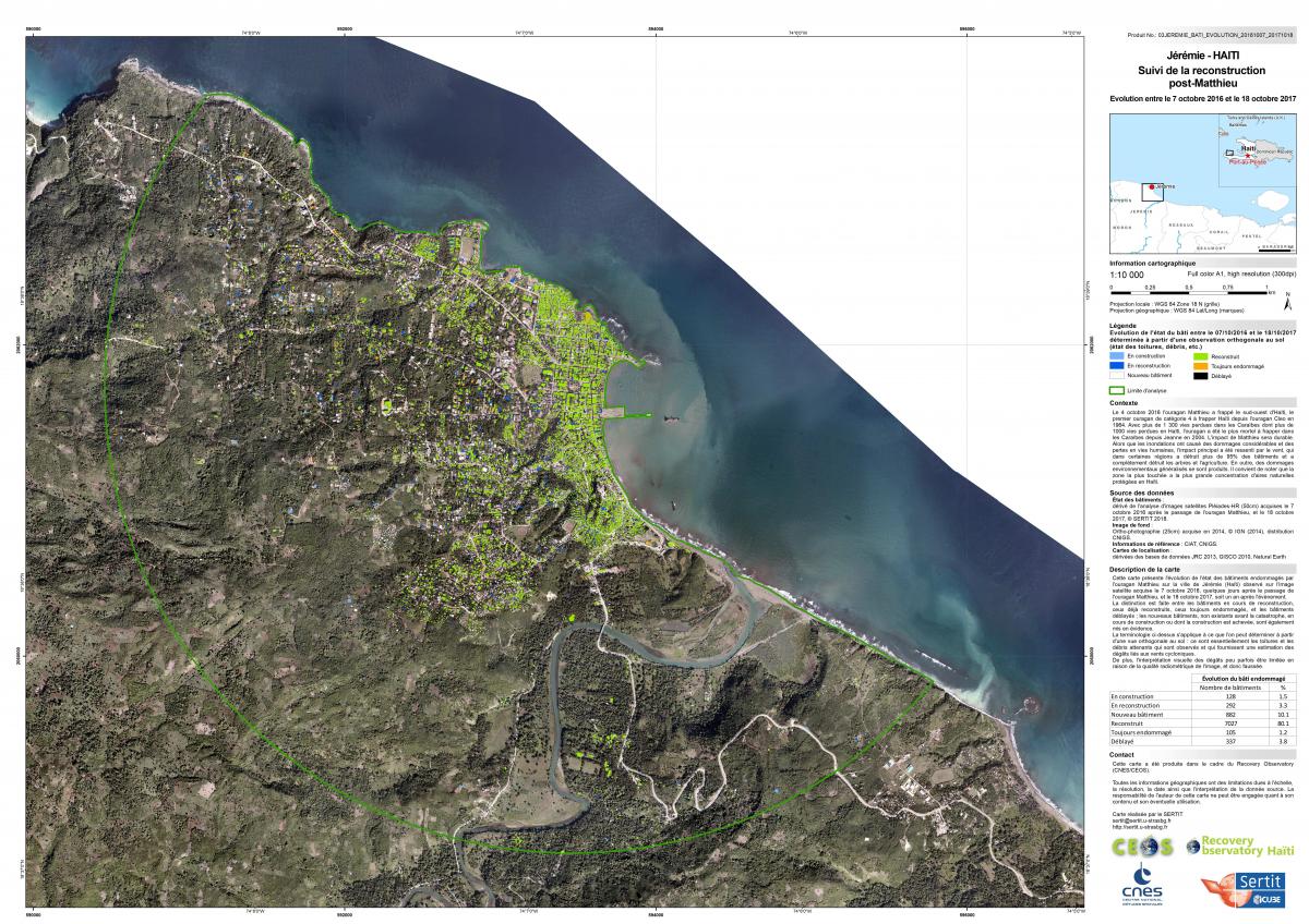
Extract from the cartography of the buildings on Jeremie a year apart
Conclusion (Summary)
This work demonstrates the contribution of satellite imagery with a very high spatial resolution for building mapping and reconstruction monitoring in urban areas. In the case of the city of Jérémie, the multi-date analysis between 2014, 2016 and 2017, shows the importance of urban dynamics, both before the hurricane Matthieu, and during the reconstruction phase.
This work made it possible to highlight certain problems or limitations, and sometimes certain solutions could be envisaged :
- Presence of geometric deformations that disturb the wedging between the images. It is necessary to use the Lidar DTM for the orthorectification process.
- Unable to see in some shady areas. The ideal could be to use acquisitions made in summer. However, the loss of the shadow may be unfavorable.
- Importance of the habitat under the woody vegetation: many buildings not visible on the image of 2014, but which appear in 2016 and 2017.
- Need to limit shooting angles to minimize geometric deformations.
The database produced as part of this work is powered solely from remote sensing data. However, it can be enriched by other sources of information or field surveys. In addition, the methodology presented is generic, and can be applied to other urban landscapes.
Finale Version is available in the attachments :
- The Finale Database in ZIP file clicking on this link
- The Final Report of the study (Version 3)
- The Final Presentation of the study (Workshop May 2018)
- The Map Post-Matthew 300dpi in jpg and pdf format (version .jgw, tfw and tif available on request)