
This page lists all the information, the exchanges and the products around the Macaya National Park monitoring
Macaya National Park is the core area of the Hotte Massif Biosphere Reserve, designated a World Biosphere Reserve by UNESCO in 2016. It has the largest concentration of endemic species in the world: 102 species of ferns, including three endemic, 141 orchids, including 38 endemic, which only exist there. The park was hit hard by Hurricane Matthew. Impact estimates ranged from 50 to 95% depending on the park areas.
Following Matthew, the park has implemented a new management plan, and RO activities have been designed to support these activities, making it possible to better understand the evolution of anthropogenic impact during the recovery period.
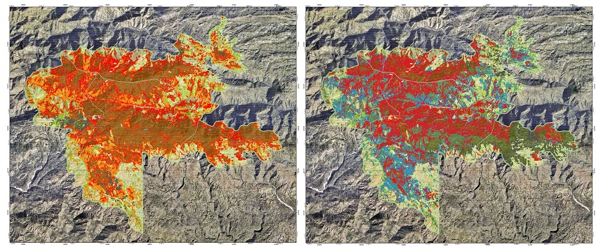
Vegetation monitoring map betwen 23/12/2016 (Left) and 08/12/2017 (Right)
Area : Red = Damaged after hurricane, Blue = regeneration under old stands, black = not analyzed (cloud)
Copernicus EMSN051 European Commission Map (SERTIT)
The first priority was to determine the impact in the park, both immediately following Matthew, and in the following years, given the new impetus for forestry activity. Funded by CNES, SERTIT worked with very high-resolution images in order to establish this impact assessment in 2017. The state of the park was assessed by the Copernicus Risk and Recovery activation in 2018 and update in a second activation in 2020. In the meantime, a more targeted activity proposed by the Inter-American Development Bank (IDB) funded by CNES aimed at understanding anthropogenic activities in the park and in bordering areas was initiated. This activity aimed at mapping the park's trails. One of the objectives of this study is to see if when economic activities are developed in the bordering area the parts of the associated park are less affected by humans.
Thematic leads:
ONEV, Ministère de l'Environnement
ANAP
Work done by CNES/SERTIT, Copernicus / European Commission
Imagery (provider) : SPOT 6/7 (CNES), Pléiades (CNES)
Analysis of Results and Outlook :
The long-term study of the park by satellite presents challenges. In the months following the hurricane, however, it was possible to measure the recovery of vegetation and to distinguish new and old vegetation. The park has a mountainous topography, which presents many shadow challenges but because of many clouds hiding the reefs. Analysis of anthropogenic impact requires very high resolution data. The analysis proposed by the IDB has revealed an impact around the areas of interest. Since 2019, vegetation has resumed its rights in unpopulated areas: the images show a strong recovery of vegetation. Unfortunately the anthropic activities still present do not serve this recovery.
List and links of elaborated products :


